Building a 670-kilometre pipeline across northern British Columbia meant moving workers, contractors, and vehicles through remote terrain, changing road conditions, and areas with limited cellular coverage. Vehicle safety had to be managed consistently across the project.
Coastal GasLink required employees, prime contractors, and subcontractors using motor vehicles on the project to operate with In-Vehicle Monitoring Systems (IVMS). These systems monitored vehicle location, speed, acceleration, deceleration, seatbelt use, and other driving data.
Coastal GasLink has since moved from construction into operation. The pipeline reached 100% pipe installation in October 2023, mechanical completion on November 6, 2023, and commercial in-service in 2024.
The project shows how IVMS compliance, GPS tracking, driver behaviour monitoring, vehicle data, and remote connectivity can be applied across a large, high-risk energy project.
TL;DR
-
Coastal GasLink required IVMS for employees, prime contractors, and subcontractors operating project vehicles.
-
IVMS data included vehicle location, speed, acceleration, deceleration, and seatbelt use.
-
IOGP identifies land transportation as a major safety risk in oil and gas operations.
-
Titan GPS provides GPS tracking, geofencing, driver monitoring, vehicle diagnostics, satellite connectivity, and ELD integration for fleets operating in demanding environments.
-
Contractors working on similar projects need fleet technology that matches the vehicle, safety, connectivity, and reporting requirements of the jobsite.
What Was the Coastal GasLink Project?
Coastal GasLink was built to move natural gas from northeastern British Columbia to LNG Canada’s export facility in Kitimat.
The route extends approximately 670 kilometres through remote parts of northern British Columbia and includes roughly 800 classified water crossings. Construction required extensive movement of workers, vehicles, equipment, and materials across a large operating area.
Pipe installation and hydrotesting were completed in October 2023. Mechanical completion followed on November 6, 2023. TC Energy reported an estimated project cost of approximately C$14.5 billion.
When Did Coastal GasLink Enter Commercial Service?
Coastal GasLink LP and LNG Canada declared the pipeline commercially in service in November 2024, with toll collection effective from October 1, 2024. The pipeline now operates as part of Canada’s LNG supply chain.
How Does Coastal GasLink Connect to LNG Canada?
Coastal GasLink delivers natural gas to LNG Canada’s facility in Kitimat. LNG Canada loaded its first export cargo on June 30, 2025. Its first two trains have combined capacity of approximately 14 million tonnes per year. Coastal GasLink provides the upstream transportation link supplying natural gas to the facility.
What Is the Status of Indigenous Equity Participation?
In March 2022, TC Energy signed option agreements allowing participating Indigenous communities along the pipeline corridor to acquire up to a 10% equity interest in Coastal GasLink LP from TC Energy’s ownership stake.
A binding option window opened in January 2026 and is expected to remain open through the end of 2026, subject to required approvals and consents.
Why Was IVMS Required on Coastal GasLink?
Large pipeline projects involve frequent vehicle movement across long distances, remote access roads, changing weather, and active worksites. Driving risk therefore becomes a major part of project safety.
The International Association of Oil & Gas Producers, or IOGP, identifies land transport incidents as historically the single largest cause of fatalities in member-company operations.
Coastal GasLink used IVMS as part of a broader approach to monitoring vehicle activity and driver behaviour across the project.
What Did Coastal GasLink’s Safe Driving Guidelines Require?
Coastal GasLink’s Safe Driving Guidelines covered driver orientation, IVMS reporting, roadside coaching, monitoring, and safety performance. IVMS was required for employees, prime contractors, and subcontractors operating motor vehicles on the project.
The system monitored:
- Vehicle location
- Speed
- Acceleration
- Deceleration
- Seatbelt use
- Other driving data
That gave safety teams greater visibility into both where vehicles were operating and how they were being driven.
How Does IOGP Report 365 Apply?
IOGP Report 365 provides guidance for managing land transportation risk, while Report 365-12 focuses on IVMS programs.
The guidance covers:
- Speed and harsh-driving thresholds
- Driver and vehicle behaviour data
- Coaching and feedback
- Data management
- Privacy
- Vehicle-integrated and camera-based systems
IVMS therefore combines vehicle technology with monitoring, review, coaching, and corrective action.
What Is an IVMS?
An In-Vehicle Monitoring System (IVMS) is a telematics system used to record vehicle and driver activity for safety monitoring, coaching, reporting, and compliance. Depending on project requirements, an IVMS can collect GPS location, driver identification, speed, braking, acceleration, seatbelt status, vehicle diagnostics, and other driving events. Some systems also include dash cameras, fatigue detection, and distraction monitoring.
How Is IVMS Different from Standard GPS Tracking?
GPS tracking primarily records vehicle location and movement. IVMS adds driver and vehicle safety data and connects that information to defined safety processes.
| Capability | Basic GPS Tracking | IVMS-Oriented Program |
| Location | GPS location and trip history | Location tied to safety monitoring |
| Geofencing | Entry and exit visibility | Site and route controls |
| Driver behaviour | Basic alerts where available | Defined speed, braking, acceleration, and driving thresholds |
| Vehicle data | Depends on hardware | Diagnostics and safety data where supported |
| Coaching | Usually separate | Behaviour data used for coaching |
| Remote coverage | Often cellular | Satellite options where required |
| Reporting | Operational reports | Safety and compliance records |
A complete IVMS program combines location data with the driver, vehicle, and reporting information required by the project.
Before You Mobilize: Test each vehicle and device combination to confirm it captures the required IVMS data, including seatbelt status, speed, harsh-driving events, ignition, and diagnostics. OBD-II and JBUS outputs can vary by vehicle.
How Does Titan GPS Address IVMS Requirements?
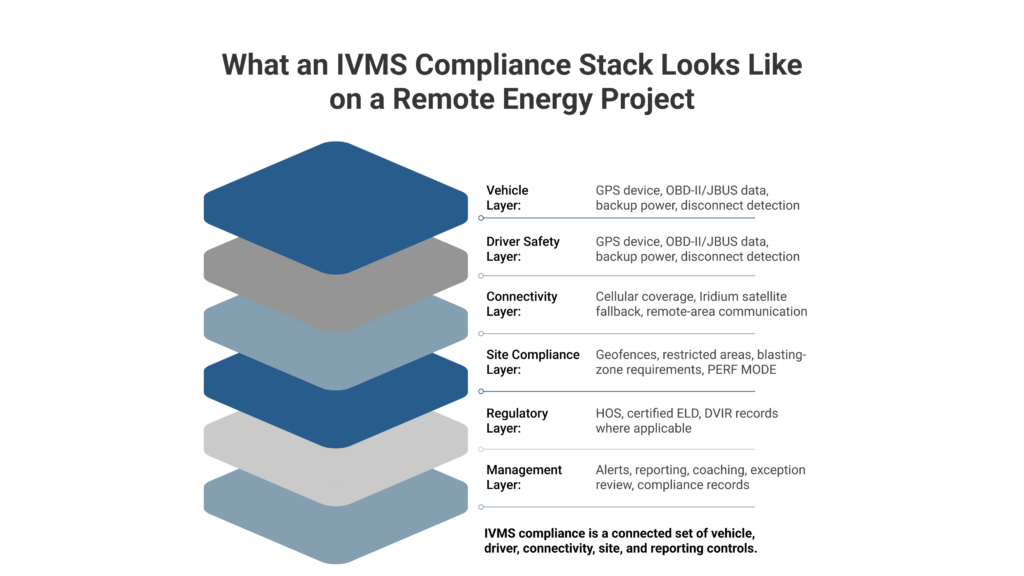
IVMS programs often require more than location tracking. Fleets may need driver behaviour data, vehicle diagnostics, reliable hardware, remote connectivity, and compliance records. Titan GPS brings these capabilities together within one fleet management platform.
How Do Live Tracking and Geofencing Improve Fleet Visibility?
Titan GPS provides live vehicle tracking, trip history, and customizable geofences around jobsites, yards, roads, camps, and restricted areas. Managers can monitor movement and receive alerts for events such as boundary crossings, ignition changes, and vehicle movement.
Across a large pipeline corridor, this creates a consistent record of where equipped vehicles have travelled and when they entered or left defined locations.
How Is Driver Behaviour Monitored?
Titan GPS can monitor:
- Speeding
- Harsh braking
- Rapid acceleration
- Route deviations
- Idling
Safety teams can review these events alongside trip history and use the data during driver coaching. Compatible hardware such as the TT6000 can also provide audible in-cab alerts when configured driving thresholds are approached or exceeded.
What Vehicle Diagnostics Can Be Captured?
Titan GPS supports OBD-II data on compatible vehicles and hardware.
Available information can include:
- Seatbelt status
- Airbag deployment
- Tire pressure
- Oil life
- Gear position
Available data depends on the vehicle and installed hardware. Fleets can match supported vehicle data with the specific IVMS requirements of a project before deployment.
How Does Driver Fatigue Monitoring Fit In?
Titan GPS offers Driver•i camera technology for monitoring safety events such as:
- Drowsiness
- Distracted driving
- Close following
The system also provides forward-collision warnings and video-based driver coaching. These capabilities extend driver monitoring beyond vehicle movement and harsh-driving events.
Where Do HOS and ELD Fit?
For regulated commercial vehicles, IVMS requirements can sit alongside hours-of-service obligations. An IVMS monitors safety-related vehicle and driver activity, while an ELD creates the electronic driving and duty-status records required under HOS rules.
Titan GPS offers a Transport Canada-certified ELD with HOS logging, DVIR functionality, and fleet integration. Transport Canada’s certified-device registry lists the Titan Android TT6A01, certification 6T38, as active under Certified Tracking Solutions.
For contractors operating regulated vehicles, this brings driver behaviour, vehicle activity, and HOS records into the same fleet environment.
Before You Mobilize: Check cellular coverage across access roads, camps, yards, and remote work areas. Where coverage drops, confirm whether satellite-capable hardware is needed before deployment.
How Does IVMS Work in Remote and High-Risk Areas?
Remote energy projects often involve cellular dead zones, isolated roads, blasting areas, long travel distances, and limited roadside infrastructure. Fleet technology needs to account for those operating conditions.
What Is PERF MODE?
Some worksites restrict radio-frequency transmissions during blasting operations. Titan GPS offers PERF MODE, which disables applicable radio transmissions from the telematics system when blasting procedures require it. Fleets can use the feature alongside site-specific blasting procedures and operating rules.
How Does Satellite Connectivity Extend Coverage?
Cellular tracking becomes less reliable once vehicles move beyond network coverage. Titan’s TT6000 is Iridium satellite-ready and can be paired with compatible satellite hardware.
Satellite connectivity extends telematics communication into areas where cellular service is unavailable, helping remote fleets maintain visibility across a wider operating area.
What Did Coastal GasLink Show About IVMS at Scale?
Coastal GasLink involved multiple contractors working across hundreds of kilometres of active construction. Applying the same vehicle-monitoring requirement across employees, prime contractors, and subcontractors created a common safety expectation regardless of who operated the vehicle.
That is where IVMS becomes more valuable on a megaproject. Location, driving events, and other required vehicle data can be measured against defined project standards rather than relying only on individual fleet policies.
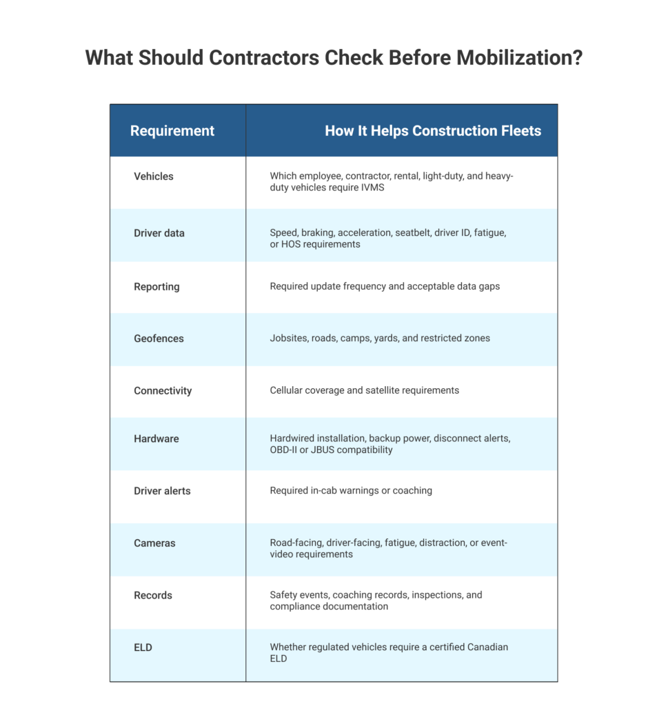
For contractors, the lesson is practical: IVMS readiness needs to be addressed before mobilization, especially when a project specifies what data must be captured, how vehicles must be equipped, and how driving performance will be monitored.
What Was Titan GPS’s Connection to SA Energy Group?
Coastal GasLink selected SA Energy Group to construct Sections 3 and 4, covering roughly 200 kilometres around Prince George and Vanderhoof. SA Energy Group was also a Titan GPS partner.
The relationship placed Titan GPS technology within the contractor ecosystem working on one of Canada’s largest pipeline construction projects.
What Can Contractors Learn from Coastal GasLink?
Coastal GasLink is operational, but similar fleet challenges continue across major energy projects in British Columbia.
- Cedar LNG is under construction in Kitimat, with delivery of its floating LNG facility planned for 2028.
- Woodfibre LNG reported in June 2026 that construction was more than 65% complete and remained on track for completion in late 2027.
- Ksi Lisims LNG received federal and provincial environmental approvals in September 2025.
TC Energy also reported in May 2026 that Coastal GasLink LP and LNG Canada had established a framework for a proposed CGL Phase 2 expansion.
Contractors working on projects of this scale need to verify vehicle monitoring, driver safety, reporting, connectivity, and compliance requirements before mobilization.
Is Your Fleet Ready for the Next IVMS Requirement?
Coastal GasLink showed what happens when vehicle safety standards extend across an entire project workforce.
For contractors, preparation begins before mobilization. Required driver data, hardware, connectivity, reporting, cameras, alerts, and ELD requirements need to be mapped against the fleet that will actually arrive on site.
Titan GPS brings together fleet tracking, driver behaviour monitoring, vehicle diagnostics, satellite connectivity, dash cameras, and Canadian ELD technology for construction, oil and gas, and remote fleet operations.
Talk to Titan GPS about configuring your fleet for IVMS and oil and gas project requirements.