
Fleet operations do not stop at city limits. For organizations working across Canada’s rural, industrial, and off-grid regions, connectivity gaps are not an inconvenience. They are an operational risk.
Remote area GPS tracking exists to solve one fundamental problem: maintaining visibility when cellular networks disappear. Oil and gas fleets traveling between well sites, forestry equipment operating deep in timber regions, mining vehicles in northern territories, and utility crews responding to remote outages all face the same challenge. Standard cellular GPS systems lose signal, data stops flowing, and fleet managers are left making decisions without real-time insight.
Titan GPS addresses this challenge through dual-mode GPS tracking, combining cellular and satellite connectivity to deliver consistent fleet and asset visibility across both populated and remote regions.
This guide explains how remote area GPS tracking works, where traditional systems fail, and how Titan GPS uses satellite telematics to keep fleets connected anywhere they operate.
TL;DR
Remote area GPS tracking ensures fleet visibility even where cellular networks fail.
Cellular-only GPS systems create blind spots that increase operational and safety risk.
Satellite connectivity enables consistent tracking across rural, industrial, and off-grid regions.
Dual-mode GPS combines cellular efficiency with satellite reliability for uninterrupted coverage.
Performance outcomes like uptime, visibility, and response time matter more than feature lists.
Why Remote Tracking Matters for Oil, Gas, and Heavy Industry Fleets
Remote operations introduce risks that are invisible in urban environments.
In Canada alone, large portions of oilfields, mining regions, forestry zones, and utility corridors sit well beyond reliable cellular coverage. When vehicles move through these areas, fleets can lose real-time location data, operational status updates, and safety visibility for hours or even days at a time.
The consequences are measurable:
- Reduced asset visibility during critical operations
- Delayed response to breakdowns or safety incidents
- Increased fuel waste due to inefficient routing and idle time
- Higher compliance exposure during audits or incident reviews
Remote tracking is not about convenience. It is about operational continuity, safety accountability, and cost control in environments where margin for error is minimal.
How Cellular GPS Tracking Works (and Its Coverage Limitations)
Cellular GPS tracking relies on two core components working together.
First, GPS satellites determine the device’s location. That location data is then transmitted through nearby cellular towers using LTE or similar mobile networks. In urban and suburban areas, this model works well. Coverage is dense, data transmission is frequent, and location updates are nearly continuous.
The limitation appears when vehicles leave populated areas.
Once a fleet enters regions with limited or no cellular infrastructure, data transmission stops. The GPS device may still calculate location, but without a network to send that data, fleet managers lose real-time visibility until the vehicle returns to coverage.
Cellular GPS is effective where networks exist. It is unreliable where they do not.
Pro Tip: When evaluating cellular GPS tracking, review coverage maps against your actual operating routes, not just the headquarters location. Fleets that regularly cross cellular dead zones often underestimate visibility gaps until data stops flowing.
Satellite GPS Tracking: The Backbone of Remote Fleet Visibility
Satellite GPS tracking removes dependence on terrestrial cellular infrastructure by transmitting data directly through low-Earth-orbit satellite networks.
Titan GPS integrates satellite connectivity through partnerships with Iridium and Globalstar, two global satellite networks designed specifically for off-grid communication.
Satellite telematics enables:
- Location updates in areas with zero cellular coverage
- Consistent data transmission across vast geographic regions
- Reliable visibility for mobile and fixed assets
- Improved safety oversight in remote environments
By leveraging satellite connectivity, Titan GPS ensures that fleets remain visible even in northern territories, offshore zones, and rural industrial corridors where cellular networks cannot reach.

Remote Asset Tracking: How to Stay Connected Beyond Cellular Coverage
Remote operations often involve more than vehicles. Fleets also manage trailers, generators, containers, heavy equipment, and fixed assets located far from infrastructure.
Remote asset tracking enables organizations to:
- Monitor asset location and movement in real time
- Detect unauthorized use or relocation through geofencing
- Improve utilization rates across remote job sites
- Reduce loss, theft, and idle inventory
Industries benefiting most from satellite-enabled asset tracking include:
- Oil and gas exploration and production
- Mining operations and support logistics
- Forestry equipment and timber transport
- Utilities infrastructure and maintenance fleets
- Rural construction and heavy equipment operations
By extending satellite connectivity to both vehicles and assets, Titan GPS provides unified visibility across the entire operational footprint.
How Dual-Mode GPS Tracking Works with Titan GPS
Titan GPS dual-mode devices are designed to automatically switch between cellular and satellite networks without driver involvement or manual configuration.
The system operates as follows:
- The device determines location via GPS satellites
- If cellular coverage is available, data is transmitted via LTE
- When cellular coverage is lost, the device seamlessly switches to satellite transmission
- Once cellular connectivity returns, the system reverts automatically
This architecture ensures high uptime, consistent asset visibility, and minimal data gaps, even as vehicles move between coverage zones multiple times per day.
Pro Tip: Dual-mode GPS delivers the most value when fleets cross coverage boundaries frequently, not just in fully remote zones. Look for systems where the transition between cellular and satellite is fully automated, with no driver action required, to maintain consistent uptime and clean historical records.
Performance Metrics That Matter in Remote GPS Tracking
Effective remote GPS tracking is measured by operational outcomes, not by feature lists or device specifications. In environments where coverage is inconsistent or nonexistent, the true value of a tracking system becomes visible through performance metrics that reflect reliability, responsiveness, and control.
The most meaningful indicators include the following.
Connectivity Uptime Across Remote Regions
Uptime measures how consistently location and status data is available, even when vehicles move in and out of cellular coverage. For remote fleets, this metric is critical. Gaps in connectivity create blind spots that increase safety risk, delay decision-making, and weaken audit trails. Dual-mode systems significantly improve uptime by maintaining communication through satellite networks when cellular signals drop.
Data Transmission Delay During Coverage Transitions
Latency becomes especially important when vehicles cross coverage boundaries multiple times in a single shift. A reliable remote tracking system minimizes the delay between data capture and data availability, ensuring that location updates, alerts, and status changes reach fleet managers without long buffering periods. Lower transmission delay supports faster intervention during incidents and more accurate operational reporting.
Asset Visibility Rate in Off-Grid Operations
Visibility rate reflects the percentage of time assets remain trackable during remote deployment. This metric directly impacts utilization, theft prevention, and recovery efforts. High visibility rates reduce uncertainty around asset location and condition, particularly for trailers, generators, and heavy equipment operating far from populated areas.
Incident Response Time Improvement
When an incident occurs in a remote location, response speed matters. Tracking systems that continue transmitting location data beyond cellular limits enable faster dispatch of assistance, clearer communication with emergency responders, and better post-incident analysis. Improved response times translate into reduced downtime, lower risk exposure, and stronger safety outcomes.
Reduction in Lost or Idle Asset Hours
Lost visibility often leads to lost productivity. When assets go dark, fleets lose insight into usage patterns, idle time, and location accuracy. Reliable remote tracking reduces unnecessary search time, improves scheduling confidence, and helps recover underutilized assets, contributing directly to cost control and operational efficiency.
Across all of these metrics, dual-mode satellite-enabled tracking systems consistently outperform cellular-only solutions, particularly for fleets operating in rural, industrial, and off-grid environments. The difference is not incremental. It is structural, driven by continuous connectivity, where traditional systems fail. 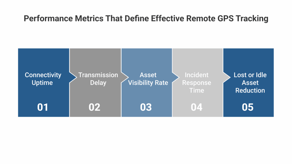
Find the Right Remote GPS Solution for Your Fleet
Not all fleets require satellite connectivity at all times. The right solution depends on where your vehicles operate, how critical visibility is to safety and compliance, and how much operational risk downtime creates.
Titan GPS supports scalable deployment models, allowing organizations to equip only the vehicles and assets that operate in remote regions while maintaining standard tracking for urban fleets.
If your fleet operates beyond cellular coverage, remote GPS tracking is no longer optional. It is a foundational requirement for safety, accountability, and operational control.
Talk to the Titan GPS team to explore dual-mode tracking options powered by satellite connectivity and designed for Canada’s most demanding operating environments.
Frequently Asked Questions
How does GPS tracking work in remote areas without cellular coverage?
In remote areas, GPS devices determine location using satellites and transmit that data through satellite communication networks instead of cellular towers. Satellite-enabled trackers continue sending location updates even in regions with no LTE or mobile service, ensuring uninterrupted visibility.
What is the difference between cellular GPS and satellite GPS tracking?
Cellular GPS relies on mobile networks to transmit data, which limits reliability outside populated areas. Satellite GPS uses orbiting satellites to send data globally, making it suitable for rural, industrial, and off-grid operations. Dual-mode systems automatically switch between both for consistent coverage.
Which industries benefit most from remote area GPS tracking?
Remote GPS tracking is especially valuable for oil and gas, mining, forestry, utilities, heavy equipment, and rural construction fleets. These industries operate in regions where cellular coverage is inconsistent and real-time visibility is critical for safety, compliance, and cost control.
Does satellite GPS tracking provide real-time location updates?
Satellite GPS provides near real-time updates optimized for reliability rather than high-frequency pings. Modern systems using low-Earth-orbit networks such as Iridium and Globalstar deliver timely, consistent updates suitable for monitoring movement, incidents, and asset status in remote environments.


