
If you manage dispatch or fleet operations, you already know the pattern. The vehicle tracking map looks fine, the schedule looks fine, and then the day goes sideways because the road reality is not fine.
A multi-vehicle slowdown, a sudden closure, an active incident, or a construction zone with restrictions can turn one late stop into a chain reaction. The hard part is not that road disruptions happen. The hard part is that most teams see them too late, or they see them in a separate tool that is not connected to the dispatch workflow.
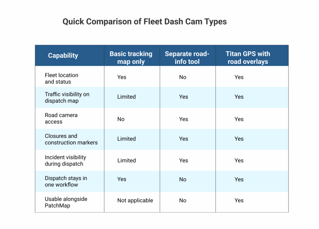
Titan GPS now brings real-time traffic and road updates into the same dashboard you already use to track vehicles, support dispatch decisions, and communicate with drivers. For fleets operating in Alberta and Ontario, this includes traffic overlays, road camera access, and map layers for closures, construction, and incidents through provincial 511 feeds, displayed within the Titan GPS map experience.
TL; DR
Titan GPS adds real-time traffic and road update overlays inside the dashboard for Alberta and Ontario fleets
Dispatch can see live road context on the same map as vehicle location for faster decisions
Road cameras add visual confirmation when conditions are unclear
Closures, construction, and incidents become easier to route around when they are visible during dispatch
PatchMap users can keep their operational map view and still add 511 layers
A New Level of Real-Time Visibility for Fleet Operators
GPS tracking answers one question: where is the vehicle?
Fleet operations need a second answer: what is happening on the road in front of the vehicle?
When those two answers live in separate places, the team is forced into guesswork:
- A dispatcher sees a vehicle moving slowly but cannot tell if it is traffic, weather, a crash, or a closure
- A customer asks for an ETA and the dispatcher must give an estimate without road context
- A driver calls in after hitting a road block, and the back office is already behind
With live road intelligence, your team can verify conditions early, reroute sooner, and communicate with more confidence.
Pro tip: Build a simple “verify before reroute” rule for dispatch. When a vehicle speed drops unexpectedly, check the traffic layer first, then open the nearest road camera if available, and only then reroute or reassign stops. This cuts reactive detours, reduces unnecessary driver calls, and makes your ETA updates more credible on the first message.
Understanding the 511 Road Network Integration
Provincial 511 services publish travel and road condition information that helps the public and commercial drivers understand what is happening on major routes in real time. That includes road camera views, traffic slowdowns, closures, construction activity, and incident updates. Titan GPS pulls these road updates into the Titan GPS dashboard for supported regions, so your dispatch team can see road conditions without leaving the fleet map or switching between separate tools.
The value is not only that the information exists. It is that it becomes usable during dispatch. When road context sits next to vehicle location, teams can make decisions while they still have options instead of reacting after a driver is already stuck.
Here is what that integration changes operationally:
- One map, one workflow: Dispatch can keep the Titan GPS map open and still understand why a vehicle is slowing down, where a backup begins, or whether a route is becoming unsafe. That reduces time lost to tab switching and back-and-forth calls with drivers.
- Shared situational awareness: Everyone is looking at the same road picture. Dispatch, supervisors, and managers can align quickly on what is happening and what the next move should be.
- Earlier, cleaner decisions: A reroute decision made early is usually cheaper than a reroute decision made late. Seeing closures, incidents, or construction markers before a vehicle reaches the choke point helps protect the rest of the day’s schedule.
- Better customer communication: When you can see road disruptions and vehicle location together, your ETA updates become more credible. You can tell a customer what is happening and what you are doing about it, instead of giving a vague delay message.
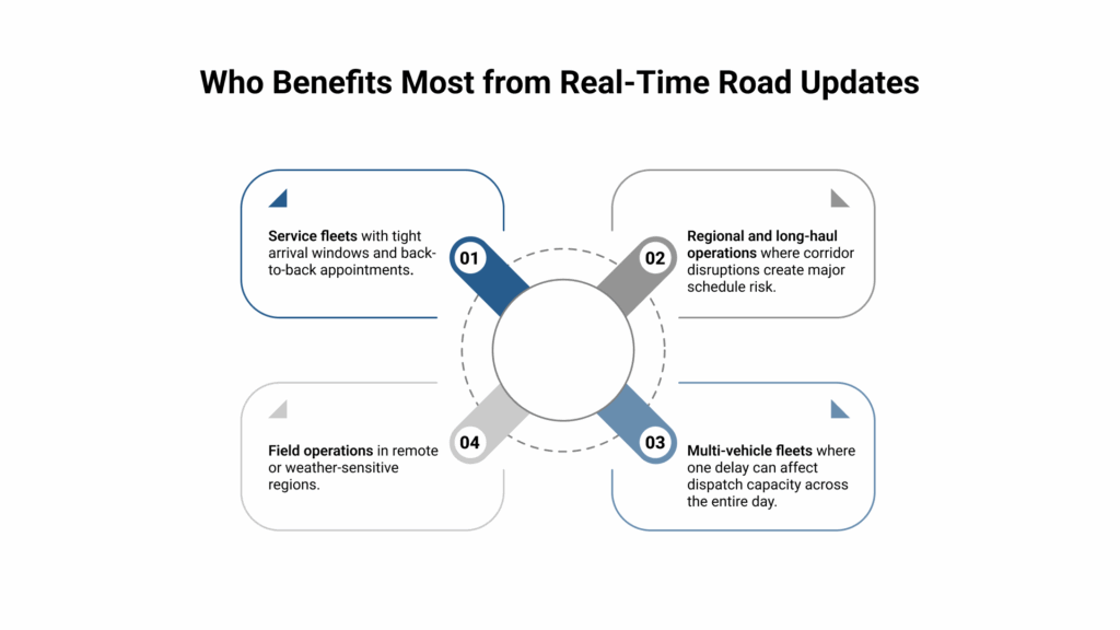
This matters most in two situations:
- When conditions change quickly: Snow, storms, crashes, sudden closures, and traffic spikes. In these moments, the difference between a smooth day and a messy day often comes down to how fast dispatch can confirm what is happening and act. Camera views and incident markers help teams decide whether to reroute, hold a dispatch, or adjust arrival windows before the situation escalates.
- When fleets operate at scale: A small delay on one vehicle becomes a scheduling problem across many stops. Once one ETA slips, the next scheduled job gets pushed, and the day becomes a chain reaction. Having the 511 road network data in the same place as your fleet map helps dispatch contain the impact early, protect capacity, and prevent one disruption from knocking out multiple routes.
Key Features of Titan GPS Real-Time Road Updates
Titan GPS real-time road updates add live traffic, camera views, closures, construction, and incident layers directly to your fleet map for supported regions. This gives dispatch the road context they need at the moment decisions are made, so reroutes and ETA updates happen faster and with fewer guesswork calls to drivers.
511 Integration for Alberta and Ontario Fleets
For fleets operating in Alberta and Ontario, Titan GPS provides access to provincial 511 road information as map layers in the dashboard. Your team can use these layers alongside real-time vehicle tracking so road disruptions are visible in the same place decisions are made.
Map Overlays for Instant Route Decisions
The simplest way to explain the value is this: overlays reduce time-to-decision.
Instead of switching tabs or asking drivers for updates, dispatch can enable overlays such as:
- Traffic conditions
- Road cameras
- Closures
- Construction notices and restrictions
- Incidents
When those overlays sit on top of the fleet map, dispatch can compare vehicle location with road conditions instantly and take action earlier.
Seamless Dashboard Sync via PatchMap
Some fleets rely on specialized map views and overlays to operate in remote or complex regions. If your team uses PatchMap, the goal is not to replace how you work. The goal is to add road context on top of it.
Titan GPS supports viewing 511 road overlays while using PatchMap, so your team can keep the map view that fits your operating environment and still see live road conditions.
Traffic Overlays: Optimize Route Planning and ETAs
Traffic is not only a delay problem. It is a planning problem. When dispatch cannot see congestion early, the day gets planned on best-case routes, and then you spend the rest of the shift trying to recover. Traffic overlays make the road reality visible while you still have time to make a smarter call.
Traffic overlays help dispatch teams in three practical ways:
- Fewer preventable delays
When you can see congestion forming, you can reroute before the vehicle commits to the slowest corridor. That matters because the cost of a delay is not only the time lost in traffic. It is also the missed arrival window, the knock-on effect on later stops, and the extra calls your team has to handle to explain what happened.
- Tighter ETAs
Customer updates get easier when the dispatcher can see both the vehicle location and the traffic pattern ahead. Instead of giving a vague estimate, you can adjust ETAs based on what the driver is actually driving into. This also reduces repeat “where are they” calls because your first update is more accurate and easier for the customer to trust.
- Cleaner scheduling decisions
Traffic affects more than the current job. It changes what the next job should be. When you can see congestion in the same view as your fleet map, dispatch can make better decisions like shifting a nearby job forward, delaying a low-priority stop, or assigning the next job to a different vehicle that has a clearer route. That protects capacity and keeps the schedule stable.
The main advantage is not that traffic data exists. It is that your team can use it inside the dispatch workflow, fast enough to prevent delays instead of only explaining them after the fact.
Live Road Cameras: Visual Intelligence for Safer Fleets
Traffic layers tell you that something is happening. Traffic cameras help you understand what it looks like. A slow traffic band could be a minor backup, a near standstill, or conditions that make driving unsafe. When dispatch can open a camera view, they get visual context that helps them make a better call and communicate more clearly with the driver and the customer.
Road cameras are useful when dispatch needs a quick reality check, especially in situations like:
- Sudden visibility drops
- Snow and icy stretches
- Severe congestion where drivers may be stopped for long periods
- Situations where a detour may be safer than the primary route
They are also helpful during route handoffs. If a dispatcher is shifting work from one vehicle to another, camera confirmation can help avoid sending the replacement driver into a route that is already deteriorating.
Pro tip: Use road cameras as a quick “go / slow / reroute” checkpoint during weather or heavy congestion. If a corridor turns red on the traffic layer, open the nearest camera before you change the plan. This keeps decisions consistent across dispatchers and avoids unnecessary detours that add time.
Road Closures and Construction Alerts: Stay Ahead of Delays
Closures and construction zones create two types of disruption:
- Time disruption: detours, backups, missed windows, longer travel time
- Operational disruption: lane restrictions, temporary access constraints, or restrictions that affect certain vehicle types
When closure and construction layers are visible inside Titan GPS, dispatch can:
- Adjust routes before vehicles hit the blockage
- Reassign stops if the schedule is no longer realistic
- Update customers earlier, with a clearer reason for the delay
- Reduce driver frustration from last-minute surprises
Construction Alerts: Dynamic Updates for Route Planning
Construction is rarely a one-day event. It often changes by phase, direction, lane configuration, or time windows.
Construction alerts are valuable because they keep dispatch aligned with changing conditions. Even small changes like a lane shift or reduced speeds can stack up across multi-stop routes. Seeing those markers early helps teams avoid cascading delays.
Incident Alerts: Respond Faster with Real-Time Data
Incidents are different from planned disruptions. They are unpredictable, and they create secondary effects.
An incident can trigger:
- Sudden congestion far beyond the incident point
- Unplanned reroutes that push drivers into unfamiliar roads
- Delays that break service level commitments
Incident overlays in Titan GPS help dispatch respond faster because the team can:
- Spot the incident marker
- See how traffic is reacting around it
- Use cameras when needed to confirm severity
- Reroute vehicles before they get trapped in a backup
- Communicate a clearer ETA update to customers and internal stakeholders
If your team can reroute 10 to 20 minutes earlier, you often prevent a 45 to 90 minute delay later. That is how live road intelligence turns into real operational improvement.
Experience Real-time Fleet Intelligence with Titan GPS
If your dispatch team is juggling multiple tools just to answer basic questions about road conditions, that is time lost every day.
Real-time traffic and road updates inside Titan GPS help your team make cleaner routing decisions, improve customer communication, and reduce the operational damage caused by unpredictable road disruptions.
If you want to see how the Alberta 511 and Ontario 511 overlays look inside your Titan GPS dashboard, book a Titan GPS demo and ask to view traffic overlays, road cameras, and incident layers in a dispatch scenario.
Frequently Asked Questions
Which regions support Titan GPS real-time traffic and road updates?
Titan GPS provides these road updates for fleets operating in Alberta and Ontario through provincial 511 integration layers shown inside the Titan GPS dashboard.
Are road cameras meant for constant live monitoring?
Road cameras are most useful for quick situational confirmation when dispatch needs to verify visibility, road surface conditions, or the severity of a disruption before deciding to reroute or delay.
What road events can dispatch see using Titan GPS overlays?
Dispatch can view traffic conditions along with map layers for road cameras, closures, construction activity, and incidents, depending on regional availability.
Can I use these overlays while using PatchMap?
Yes. Titan GPS supports using road update overlays alongside PatchMap so teams can keep their preferred operational map view and still access road intelligence.


